(GPSの性能と能力で新しいApproach Design(デザイン)も可能になりました。 With GPS:
- Approach designs are not limited by ground-based navaids. 地上に存在する施設に制限されない。
- Approaches are easy to create for small airports that cannot afford ground-based navaids.
地上設備を持てない空港でもIFR Approachが可能になる
- Problematic designs, such as procedure turns, are easy to avoid. 問題の出やすいProcedure Turnなどを省く事が可能になる。
Overlay and Stand-Alone Approaches
Overlay
- Existing VOR or NDB approaches are allowed. 既にあるVORやNDBアプローチと同じコースをGPSで飛行する。
- Waypoints must be in the database, not manually entered.
Waypointはデータベースに入っている事が条件で、手動では入力する事は出来ません。
- The procedure title must include the words "or GPS" in order to use GPS when flying that procedure.
GPSでアプローチを行う時は必ず、「GPS」と書かれている必要があります。
- GPS data always refers to the distance to the next waypoint, while distances on approach charts often refer to the distance from the previous waypoint. GPSのデータは次のWaypointまでの距離です。チャートでは最後のWaypointからの距離。違いが有りますので注意が必要です。
Stand-Alone GPS and RNAV (GPS)
Stand-Alone and RNAV GPS procedures use Terminal Arrival Areas (TAAs), which: これはGPS専用もしくはGPSを含むRNAVと言う意味です。(RNAVには色々と有りますが、コンピュータなどで自動的にWaypointまで、コースを知らせてくれる物です。) また、その時はTAAと言うのが使われます。
- Typically align with runway and have a “T” shape. 通常は滑走路の延長線上に作られていて、T-字型のコースが有ります。
- Show MSAs within quadrants of the plan view and not as a single MSA for the whole procedure.
Quadrantsと言われる広範に渡るMSAが使われます。決められたポイントからの扇状で最低高度が示されます。
Terminal Arrival Areas
GPS や RNAV(GPS)の特徴は Terminal Arrival Area (TAA)を使います。TAAはEnrouteからApproachに入るのがスムーズに行えるように、広範囲での最低高度を設定されています。 RNAV(GPS)なら基本的にはどの方向からでもWaypointに直線で飛行できますからね。
ある程度のコースは決まってますが、TAAには3つのエリアがあります。
- The straight-in area
- The right base area
- The left base area
Initial approach Waypointからの高度が示されています。もし「障害物や山でTAAの設定が無理な場合」は通常のMSAが表示されています。
RNAV (GPS)
多くのGPS Approachは RNAV機でも使える様にRNAV(GPS) Approachに変更されて行っています。 一部の物にはRequired Navigational Performance (RNP) が定められており、そのRNPがあれば、GPS以外のRNAVでも飛行が可能になります。. If the required RNP is obtained, the type of RNAV system will not be named in the procedure title.
LNAV, LNAV/VNAV, and LPV Approaches
基本的なRNAV(GPS)アプローチは Lateral Navigation (LNAV) approachですが、WAASのお陰で2種類のアプローチが可能になりました。 Approach with Vertical Guidance (APV), 精度の向上により上下の情報も使えるようになりました。Lateral Navigation/Vertical Navigation (LNAV/VNAV) と Localizer Performance with Vertical Guidance (LPV)が生まれました。
LNAV Approaches
Your students need to know that LNAV approaches:
- NON-precision approaches. (AVPとして区別する事も可能, Approach with Vertical Guidance)
- Require as minimum equipment an approved IFR GPS receiver.
- Do not have vertical guidance. GSのような上下の情報は有りません。(使えません)
- Have a minimum descent altitude (MDA) and a missed approach point (MAP). DHでは無く、MDAがあります。
LNAV/VNAV Approaches
LNAV/VNAV approaches では LNAVが左右を、Glide pathをVNAV部分を教えてくれます。 VNAVはGSの代わりになります。
- LNAV/VNAV approaches provide a stabilized glide path. ILSの様な、スムーズな下降が可能になります
- Even though an LNAV/VNAV approach has a published decision altitude (DA), it is not a precision approach.
DAが有りますがPrecision Approachにはなりません。
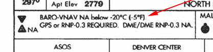
- When using Baro-VNAV, the procedure will most likely not be authorized below a specific temperature.
- Baro-VNAV, Barometric Vertical Navigation (Capacity)とも言いう仕組みで、特殊な気圧高度計をGPSとリンクさせて使う仕組みです。
- WAASの機能が無いGPSで使う事が有りますが、かなり高価で通常の飛行機には付いていません。
- Baro-VNAVは、他の気圧高度計と同じ仕組みですので、極寒の気温では十分な性能が得られえません。
- 気温が低いと、航空機の気圧高度計が実際よりも高く示しますよね。
- この危険性の為に、Baro-VNAVが可能な気温が、アプローチ毎に設定されています。
-
LNAV/VNAVが、単なるLNAVよりもMinimumが高い場合があるのは、この低温度による誤差の為です。
LPV Approaches
- Have a DA. DAがあります。
- Precision Approachではありません。ICAOの基準を満たしていません。
- The approach Procedure Minima MAY hade DA as low as 200 feet HAT with visibility minimum as low as 1/2 mile. DAは200 feetまで下げられている場合もあり、Visibilityも0.5マイルまで認められる場合があります。
- Use a database-derived glide path that can be flown to a DA, similar to an ILS. データベースの情報によって作られたGSで有る事。
- IF the GPS is WAAS enabled, it will inform you if LPV is available and activated.
GPSがWAAS付なら、LPV使用の可能性を教えてくれるそうです。
私には細かい情報が無いので不明なのですが・・・・
LAASがGBASに変わり、Approach Minimumも200 feet HATまで向上しましたが、テキストの方がまだ訂正されていない可能性があります。
WAASが無くてもLAASがあればPrecision Approachが可能な気がするのですが、私には確認方法がありません。
その為、LPVやVNAVの記述が古い可能性があるので、飛行前はGPSのPOHなどを確認ください。 お願いします。
次へ
Top : Operation & System : Equipments : Navigation : Approach Design : GPS Approach : Common Mistakes