FAAの筆記試験(Knowledge Exam)について。 : Privateの筆記試験について : PVTの問題へ : IFR、筆記の解説 : IFR問題へ
Private Pilot : 2007年 Airman Knowledge Test Question (Written Exam)
図へ移動する (Figure 21, Figure 22, Figure 23, Figure 26 ,Figure 28 Figure 52)
201.
(Refer to figure 21.) En route to First Flight Airport (area 5), your flight passes over Hampton Roads Airport (area 2) at 1456 and then over Chesapeake Municipal at 1501. At what time should your flight arrive at First Flight?
A) 1516.
B) 1521.
C) 1526.
202.
(Refer to figure 22, area 2.) Which airport is located at approximately 47° 39 minutes 30 seconds N latitude and 100° 53 minutes 00 seconds W longitude?
A) Linrud.
B) Crooked Lake.
C) Johnson.
203.
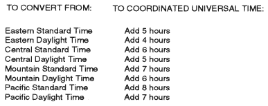
(Refer to figure 28.) An aircraft departs an airport in the eastern daylight time zone at 0945 EDT for a 2-hour flight to an airport located in the central daylight time zone. The landing should be at what coordinated universal time?
A) 1345Z.
B) 1445Z.
C) 1545Z.
 図28 左下のアップ
時差問題の回答例 : この問題の翻訳例
204.
(Refer to figure 23.) What is the magnetic heading for a flight from Priest River Airport (area 1) to Shoshone County Airport (area 3)? The wind is from 030° at 12 knots, and the true airspeed is 95 knots.
A) 118°.
B) 143°.
C) 136°.
205.
(Refer to figure 23.) What is the estimated time en route from Sandpoint Airport (area 1) to St. Maries Airport (area 4)? The wind is from 215° at 25 knots, and the true airspeed is 125 knots.
A) 30 minutes.
B) 34 minutes.
C) 38 minutes.
206.
(Refer to figure 23.) Determine the estimated time en route for a flight from Priest River Airport (area 1) to Shoshone County Airport (area 3). The wind is from 030 at 12 knots and the true airspeed is 95 knots. Add 2 minutes for climb-out.
A) 29 minutes.
B) 27 minutes.
C) 31 minutes.
207.
(Refer to figure 23.) What is the estimated time en route for a flight from St. Maries Airport (area 4) to Priest River Airport (area 1)? The wind is from 300° at 14 knots and the true airspeed is 90 knots. Add 3 minutes for climb-out.
A) 38 minutes.
B) 43 minutes.
C) 48 minutes.
208.
(Refer to figure 21, area 3.) Determine the approximate latitude and longitude of Currituck County Airport.
A) 36°24'N - 76°01'W.
B) 36°48'N - 76°01'W.
C) 47°24'N - 75°58'W.
209.
(Refer to figure 26.) Determine the magnetic heading for a flight from Fort Worth Meacham (area 4) to Denton Muni (area 1). The wind is from 330° at 25 knots, the true airspeed is 110 knots, and the magnetic variation is 7° east.
A) 003°.
B) 017°.
C) 023°.
210.
(Refer to figure 52.) If more than one cruising altitude is intended, which should be entered in block 7 of the flight plan?
A) Initial cruising altitude.
B) Highest cruising altitude.
C) Lowest cruising altitude.
図へ移動する (Figure 21, Figure 22, Figure 23, Figure 26 ,Figure 28 Figure 52)
Private Pilot Knowledge Test (Private Written Exam) 05/23/2007 :
2008年の問題へ