FAAの筆記試験(Knowledge Exam)について。 : Privateの筆記試験について : PVTの問題へ : IFR、筆記の解説 : IFR問題へ
2008-09 Private Pilot Knowledge (Private Written) Exam 米国自家用操縦士筆記試験
141. PLT064
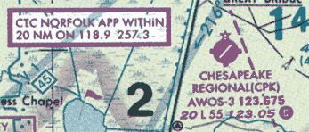
(Refer to figure 21, area 2.) The elevation of the Chesapeake Regional Airport is
A) 20 feet.
B) 36 feet.
C) 360 feet.

142. PLT064
(Refer to figure 21, area 5.) The CAUTION box denotes what hazard to aircraft?
A) Unmarked blimp hangers at 300 feet MSL.
B) Unmarked balloon on cable to 3,000 feet AGL.
C) Unmarked balloon on cable to 3,000 feet MSL.
143. PLT064
(Refer to figure 22.) On what frequency can a pilot receive Hazardous Inflight Weather Advisory
Service (HIWAS) in the vicinity of area 1?
A) 117.1 MHz.
B) 118.0 MHz.
C) 122.0 MHz.
144. PLT064
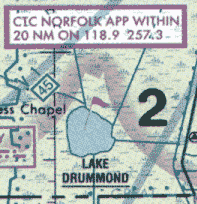
(Refer to figure 21, area 2.) The flag symbol at Lake Drummond represents a
A) compulsory reporting point for Norfolk Class C airspace.
B) compulsory reporting point for Hampton Roads Airport.
C) visual checkpoint used to identify position for initial callup to Norfolk Approach Control.

145. PLT064
(Refer to figure 22.) Which public use airports depicted are indicated as having fuel?
A) Minot Intl. (area 1) and Mercer County Regional Airport (area 3).
B) Minot Intl. (area 1) and Garrison (area 2).
C) Mercer County Regional Airport (area 3) and Garrison (area 2).
146. PLT101
(Refer to figure 26, area 2.) The control tower frequency for Addison Airport is
A) 122.95 MHz.
B) 126.0 MHz.
C) 133.4 MHz.
147. PLT064
(Refer to figure 24.) The flag symbols at Statesboro Bullock County Airport, Claxton-Evans County
Airport, and Ridgeland Airport are
A) outer boundaries of Savannah Class C airspace.
B) airports with special traffic patterns.
C) visual checkpoints to identify position for initial callup prior to entering Savannah Class C
airspace.
148. PLT101
(Refer to figure 26, area 4.) The airspace directly overlying Fort Worth Meacham is
A) Class B airspace to 10,000 feet MSL.
B) Class C airspace to 5,000 feet MSL.
C) Class D airspace to 3,200 feet MSL.
149. PLT064
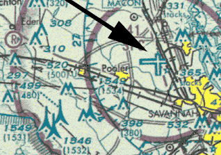
(Refer to figure 24, area 3.) What is the height of the lighted obstacle approximately 6 nautical miles
southwest of Savannah International?
A) 1,500 feet MSL.
B) 1,531 feet AGL.
C) 1,549 feet MSL.

150. PLT012
(Refer to figure 22.) The terrain elevation of the light tan area between Minot (area 1) and Audubon
Lake (area 2) varies from
A) sea level to 2,000 feet MSL.
B) 2,000 feet to 2,500 feet MSL.
C) 2,000 feet to 2,700 feet MSL.
Private Pilot Knowledge Test (Private Written Exam) 2008年09月18日より出題
問題が削除されただけなので、CFI Japanでは大きく変わるまで3月分を中心に和訳と解説を続けます。