161. - PLT012
(Refer to figure 22.) What is the estimated time en route from Mercer County Regional Airport (area
3) to Minot International (area 1)? The wind is from 330°at 25 knots and the true airspeed is 100
knots. Add 3-1/2 minutes for departure and climb-out.
A) 44 minutes.
B) 48 minutes.
C) 52 minutes.
和訳と解説へのリンク
162. - PLT012
(Refer to figure 28.) An aircraft departs an airport in the mountain standard time zone at 1515 MST
for a 2-hour 30-minute flight to an airport located in the Pacific standard time zone. What is the
estimated time of arrival at the destination airport?
A) 1645 PST.
B) 1745 PST.
C) 1845 PST.
和訳 : 解説
163. - PLT012
(Refer to figure 26.) What is the estimated time en route for a flight from Denton Muni (area 1) to
Addison (area 2)? The wind is from 200°at 20 knots, the true airspeed is 110 knots, and the
magnetic variation is 7°east.
A) 13 minutes.
B) 16 minutes.
C) 19 minutes.
和訳と解説へのリンク
164. - PLT012
(Refer to figure 23.) Determine the magnetic heading for a flight from St. Maries Airport (area 4) to
Priest River Airport (area 1). The wind is from 340°at 10 knots, and the true airspeed is 90 knots.
A) 320.
B) 327.
C) 345.
和訳とリンク
165. - PLT012
(Refer to figure 24.) What is the estimated time en route for a flight from Allendale County Airport
(area 1) to Claxton-Evans County Airport (area 2)? The wind is from 100°at 18 knots and the true
airspeed is 115 knots. Add 2 minutes for climb-out.
A) 27 minutes.
B) 30 minutes.
C) 33 minutes.
和訳と解説へのリンク
166. - PLT012
(Refer to figure 24.) Determine the magnetic heading for a flight from Allendale County Airport (area
1) to Claxton-Evans County Airport (area 2). The wind is from 090°at 16 knots, and the true
airspeed is 90 knots.
A) 208°.
B) 212°.
C) 230°.
和訳とリンク
167. - PLT012
(Refer to figure 24 and 59.) Determine the compass heading for a flight from Claxton-Evans County
Airport (area 2) to Hampton Varnville Airport (area 1). The wind is from 280°at 08 knots, and the
true airspeed is 85 knots.
A) 033°.
B) 038°.
C) 042°.
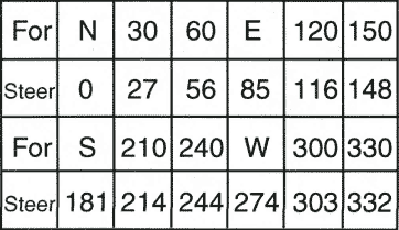
Figure 59
和訳とリンクに数値
168. - PLT064
(Refer to figure 21.) Determine the magnetic course from First Flight Airport (area 5) to Hampton
Roads Airport (area 2).
A) 141°.
B) 321°.
C) 331°.
和訳と説明リンク
169. - PLT012
(Refer to figure 27.) Determine the magnetic course from Breckheimer (Pvt) Airport (area 1) to
Jamestown Airport (area 4).
A) 180°.
B) 188°.
C) 360°.
和訳と説明リンク
170. - PLT012
(Refer to figure 23.) What is the magnetic heading for a flight from Priest River Airport (area 1) to
Shoshone County Airport (area 3)? The wind is from 030°at 12 knots, and the true airspeed is 95
knots.
A) 118°.
B) 143°.
C) 136°.
和訳とリンクに数値